When I first discovered that mountain bike orienteering existed, I knew that I wanted to try a race – the problem was that I didn’t own a mountain bike! But this summer, I won one at the Subaru Bruce Peninsula Multisport Race. Problem solved! I signed up for the “novice” course of the STAR Tracks Mountain Bike Adventure, organized by the STARS Orienteering Club and held at Albion Hills Conservation Area in Caledon.
As a fairly new mountain biker, I thought that the 30-60 minute race option, intended for those who have basic trail riding and trail map navigation skills, would be best for me. But Barb, the event director, suggested that I check out the Albion Hills trails, and if I wanted to, I could switch into the “open” course, intended for intermediate to strong bikers and navigators. I headed to Albion Hills with a friend, had a blast on the single and double track trails, and decided to switch to the open course.
On race morning, I arrived so early that only Barb was there. I helped carry some things to the chalet, and helped set up the tent for protection from what we all knew may arrive during the race – wild winds and heavy rain. Once everything was organized, I checked in, signed a waiver, cleared and checked my SI (timing) stick and got my race map.
Preparing my route pre-race. [Photo by Ilona Dobos]There were 15 checkpoints that had to be found in order within the 2 hour limit, with all of them found on the trails (no bushwhacking required), some of them single track, one way trails. When planning my route, I had to be careful to note which trails ran in which direction, or risk adding extra distance when I reached the trail and was faced with a “no entry” sign.
There was a short pre-race briefing, during which we were warned that with the rains overnight, the clay and roots may be very slippery. We were instructed to start the race when we were ready, and to verify control #s before inserting our SI sticks, because there would be controls from both the novice and open courses out there, and if you punch the wrong control, you get a “mispunch” (and no official finish). The map above shows what numbers we were actually looking for in the forest (e.g. control 1 would read 150). I spent 5-10 minutes planning my route, then lined up to start.
Lined up and ready to go. [Photo by Ilona Dobos]Racers were started in 30 second intervals. When instructed to go, I inserted my SI stick into the start control, then headed out. I had tucked my map (in a plastic sleeve) into the left leg of my shorts, knowing that I would have to continually take it out to look at it. I tried to memorize what I would have to do at the next couple of junctions (e.g. left, left, right) to reduce the number of times I had to stop and look at the map.
Because I started just 30 seconds after the two people ahead of me (who were working together), I caught them quickly, and several of us arrived at the first checkpoint together.
The trails were a mixture of double track and single track, flat and very hilly, straight and very curvy with tight turns.
At some point, I started working with a racer name Kevin, and later, we picked up another racer named John. Each time I join forces with others I remember how much more fun it is to orienteer in a team. I love the challenge of doing it by myself, but facing trials and tribulations and celebrating successes is fun with others!
I felt good on the trails, and only fell once – from a standstill, at a control, right in front of the race photographer Ilona Dobos! I had inadvertently put my foot down in a ditch.
Looks like we’re chuckling over my tumble. [Photo by Ilona Dobos]Keeping my map in my shorts worked out okay, but at times I also held the map between my teeth when I knew I would need to look at it frequently. It wasn’t so easy to see when it opened up in my face. “How’s that working for you?” I heard at one point! I resorted to holding it in my left hand at times while I rode. Some people used handlebar mounted map holders, while several others used dollar store chip bag clips – I think I’ll try that next time! The advantage of the bike mounted map holder is that it rotates, so that you can easily turn the map so that it is facing the correct way as you turn corners.
Most of the controls were easy to find, but a few took a little longer than they should have because of poor route choices or missed trails. At one point, Kevin and I did a loop only to find ourselves where we started – we had missed a turn. I think it was around this point that he loaned allen keys to another racer whose handlebars kept dropping.
We had been told in the pre-race briefing that if we weren’t at control #7 within 1 hour of starting, then we should skip 8, 9, 10, and 11, and go straight to 12. We were heading to #7 at around 51 minutes for me (a little longer for Kevin, who started before me). I was hopeful that I could finish within the time allotted, and Kevin just wanted to find all the controls (which he hadn’t managed to do on his previous attempts at this race).
At one point during the race it rained, but it was very short lived. The temperature was fantastic, and higher than expected for a day in mid October.
Near the end of the race my legs were getting tired! I had to walk up a couple of steep grassy hills. I figured I’d walk it just as fast as I’d ride it at that point.
As I got closer and closer to control 15, I realized that it was still possible for me to finish within the 2 hours. Coming out of the forest and onto the grass near the chalet, there were lots of cheers for me and the others finishing ahead of me and behind me.
In the end, I found all controls and finished in a time of 1:52:01! I had so much fun. The single track trails are by far my favourite.
There was fruit and cookies outside the chalet, where racers compared route choices with others.
Done! [Photo by Ilona Dobos]It turns out that I finished 2nd out of 8 women in the open course. You can see all the splits here. There were also masters and junior age groups as well.
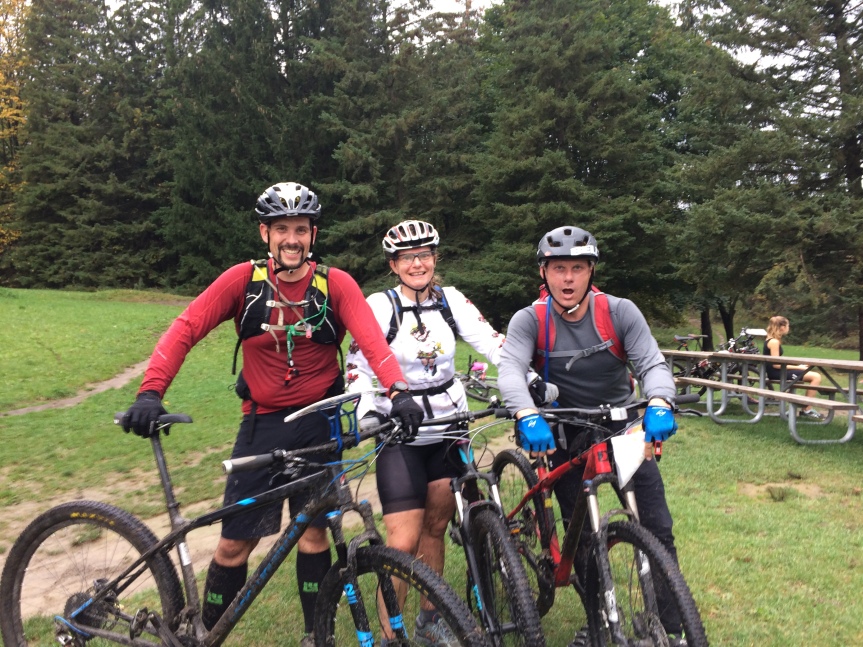
You can’t see here how muddy I got! [Photo by John] With my new racing buddies, John and Kevin. [Photo by Ilona Dobos] Thanks to the STARS Orienteering Club for such a great race. Can’t wait for the next one!
Curious to see how the planned menu for my hike of the full length of the Coastal Trail at Lake Superior Provincial Park compared to our actual menu, whether we were satisfied with the food we brought or had constantly rumbling tummies? Read on!
The planned menu is posted just below, but additional information can be found in my original post on the menu.
Where we planned to use a recipe, you’ll see a (F), (L) or (T) after the recipe name (and the corresponding page number). The books are as follows:
A Fork in the Trail by Laurie Ann March (F)
LipSmackin’ Backpackin’ by Christine and Tim Conners (L)
The Trailside Cookbook by Don and Pam Philpott (T)
PLANNED MENU
All changes to the planned menu are indicated in red text in the table below. We made a few changes before the trip:
naan bread replaced corn bread and bannock, because it weighs less and required us to bring less fuel (to bake the bread) – however, there is something to be said for warm, freshly baked bread on the trail!!
store bought trail mix replaced pizza gorp and honey mustard gorp because Cheryl ran out of time to prepare them
homemade energy bars replaced Harvest Oat Squares because Cheryl’s daughter made them and saved her time!
ACTUAL MENU
My favourite meal was Thanksgiving on the Trail, which is essentially turkey, mashed potatoes, stuffing, cranberries and gravy. I would definitely make it again!
Our most memorable meal may be our egg veggie/bacon/cheese wraps… as soon as I added boiling water to our dehydrated eggs, they turned bright orange… we tasted them, and they weren’t eggs, but Kraft Dinner cheese powder!!! Not sure how that happened. I’ve never intentionally bought Kraft Dinner cheese powder before. Must have been a mix-up in a bulk bin!
Pasta Alfredo with dehydrated veggies and sauce, and topped with Parmesan cheese.
The only meal that needs adjustment in the future was our rice cereal on day 5. It wasn’t filling enough as is, and could have used more fruit or nuts.
Overall, we were happy with our food choices! We did come home with some leftover trail mix, and some of the food from day 8.
Here is a complete list of all the things we had with us on our hike of the full length of the Coastal Trail at Lake Superior Provincial Park. We brought separate gear for car camping at Agawa Bay our first night (but didn’t end up car camping), and our last night. I didn’t use any of the separate gear, other than bringing blankets into the tent when I thought it was going to be quite cold with the wind (it wasn’t).
Clothing (including what I was wearing):
2 bras
2 pairs underwear
3 pairs socks
1 pair zip-off pants
2 t-shirts
1 long sleeved shirt
1 lightweight MEC Uplink hoodie
1 rain coat
1 rain pants
1 winter hat
2 pairs fleece gloves
1 pair dish gloves to keep fleece gloves dry
1 long johns top and bottom
1 pair hiking boots
1 pair sandals
1 baseball hat
compression bag for clothes
sunglasses
quick dry towel
toiletries
1 watch
Kitchen:
2 bowls
2 spoons
1 dishcloth
1 six cup pot and lid lightweight
dish soap
pancake flipper
parchment paper
2 insulated mugs
1 nalgene bottle (400 ml)
2 large ziplocs marked with a line at 2L for treating water
water treatment drops
2 water bladders (2 L size)
MSR Dragonfly stove
MSR Dragonfly stove servicing kit
KIHD stick stove
1 flint
Outback oven tea cosy
Outback oven scorch protector (not used)
Matches (several boxes)
700 ml white fuel split between 2 bottles of 325 ml (one filled up, one filled to the maximum fill line)
1 Swiss army knife (not used)
1 pocket knife
1 bear bag with bell on it (waterproof bag)
1 bear bag without bell on it (waterproof bag) (not used)
rope for hanging bear bag
homemade tarp plus thin lightweight rope x5
food!
Sleeping:
1 Sierra Designs Zilla 2 tent
1 MEC Perseus -7 sleeping bag
1 North Face -7 sleeping bag
1 pillow
1 thermarest 3/4 length
1 thermarest full length lightweight
2 compression bags for sleeping bags
2 bags for thermarests
Miscellaneous:
2 headlamps with extra batteries
1 bear spray (not used)
1 sunblock
2 cameras with extra batteries
1 GoPro
1 camera tripod
1 park map
1 compass (not used)
1 GPS with extra batteries
2 cell phones
1 Garmin InReach SE+ satellite 2-way communication device
2 driver’s licences, credit cards and money
1 emergency kit (Gorilla tape, buckles, dental floss, notepad and pencil, matches, mini bungees, emergency blanket, fire starting materials, needle and thread)
1 first aid kit (miscellaneous bandaids, gauze, tape, compression wrap)
In previous visits I had hiked different sections of the Coastal Trail, which runs from Chalfant Cove in the North to Agawa Bay in the South, but I had never hiked its full length – or anything close to it! With my husband and kids I hiked from Katherine Cove north to Robertson Cove, spending one night camping in the backcountry. We loved it, and I was eager to explore the entire trail with my friend Cheryl.
The park describes the Coastal Trail as follows:
The most challenging and demanding trail in the park, the Coastal Trail takes you along the high cliffs and rocky beaches of Lake Superior. The trail extends from Agawa Bay to Chalfant Cove.
The trail ascends and descends over cliffs and rocky outcrops and crosses beaches of boulders and driftwood. Use extreme caution when hiking this difficult terrain. The rocks can be very slippery, especially when wet with dew, fog or rain. Windblown trees may obstruct the trail.
Blue, diamond-shaped symbols mark where the trail enters forested areas. Rock cairns mark exposed sections. Generally the trail hugs the coastline. If you lose the trail, continue along the shore and eventually you will find the trail again.
South of Gargantua, the Coastal Trail is extremely rugged and very demanding. Between Gargantua and Rhyolite Cove the trail climbs over 80 metres (260 ft.) to spectacular vistas over the lake.
The park’s geology is most dramatic on the coast where waves have exposed the rock shoreline. Rhyolite and Beatty coves are particularly interesting. Along the way, sand and cobble beaches are nestled in coves, providing shelter for campsites.
All backcountry campsites are available on a first-come, first-served basis. Campsites along the coast are shared by hikers and paddlers.
From Friends of Lake Superior website: http://www.lakesuperiorpark.ca/index.php/park-info/park-area
Hiking the Entire Length of the Coastal Trail
Take a look at my video trip report. (Note that in a couple of sections the heavy wind makes it a bit hard to hear what I’m saying. Just turn the volume up! I’ve also added a bit of text so that key information isn’t missed.)
Day 1: Thursday, September 28 (South-western Ontario to Lake Superior Provincial Park)
At 6:06 AM we were on our way to Lake Superior! We stopped into the Twilight Resort just south of the park to confirm our shuttle for the next morning. We had arranged to be driven from the Visitor Centre at Agawa Bay to Gargantua, where we would start our hike the next morning by hiking the northern section of the trail. However, we made good time driving to the park, so we decided to ask whether we could get a shuttle that night instead of the next morning. Our shuttle driver agreed, so after paying, we headed for the park and the Visitor Centre to pay for our backcountry permit, get changed into our hiking gear, and wait for our 5:30 PM pick-up. Before we left, we chatted with the Park Interpreter, who gave us some tips, and told us to come back once we were done to let her know how it went.
Our driver arrived in a pick-up truck and we headed for Gargantua. It was a 20 minute drive to Gargantua Road, and then 42 minutes of speed, bumps, sudden braking, swerving, and general roller-coaster like driving. I guess it comes with the territory when you’ve been running shuttles for 30 years and know the (single lane!) road like the back of your hand. We were so relieved to get out of that truck, both of us feeling pukey.
We walked a mere 300 m to our first campsite on Lake Superior. We set up a tarp in case of rain, our tent, and a bear bag rope over a tree branch. We were surprised to find tiny black flies (not the black flies I’m familiar with) attacking our heads and making us itchy. Thankfully, we only saw them the first night.
At midnight we awoke to the sound of thunder far in the distance. Over the next hour or so, it got progressively closer, until it was very very close. Heavy rain started, and with it, puddles formed in our two vestibules. Then Cheryl noticed that there was water flowing below our tent floor – and a lot of it. The water accumulated more quickly on Cheryl’s side, so she tried to hold the tent footprint up to make sure the water went under it. Once the storm passed and the rain nearly stopped, we decided to move the tent. We couldn’t believe it when we moved it and saw that the only puddle in the campsite was the one where our tent had been – at a depth of about an inch of water! We moved the tent to higher ground, and were shaking our heads because when we set the tent up, it didn’t look like a depression to us! Were we ever wrong. Thankfully, everything inside the tent stayed dry!
Day 1 hiking summary: Gargantua road to 1st campsite (300m)
Day 2: Friday, September 29
On our first full day of hiking, we were up at 7 AM and on the trail at 9:15. We find that it always takes us about 2 hours to get going, from the moment our alarm goes off to the first step away from our campsite. Our routine was to pack up everything inside the tent before getting out of it, pack up the tent, cook a hot breakfast (you can find our full menu here, and a review of the menu here), and then pack up the tarp, kitchen stuff and everything else. Two hours seems like a long time, but very little of that time is us just sitting there enjoying our hot cereal and tea!
We headed north for Chalfant Cove, hoping to be able to also see Warp Bay and Devil’s Chair on our way back. We thought that Chalfant Cove was 7 km from the Gargantua Road, but we learned as we hiked and read the distance markers that it was actually 7 km from Gargantua Harbour, which was 2 km from the road. So, our hike would be even longer than expected. The hike was easy but boring, through woods that seemed never-ending. There were very few points that were scenic. We had decided to do Chalfant Cove first at the recommendation of the Park Interpreter, and if there was time, to do the other “fork” of the trail on the way back. By the time we reached Chalfant Cove, which was very underwhelming, we pretty much knew we would be heading straight back to the campsite. We had already hiked 10 km! There was one pretty spot close to Chalfant Cove – Indian Harbour, and a nice set of rapids in the woods, but that was pretty much it. The return hike was long, and perhaps even more boring. Our feet were getting sore from the hard ground. Once we reached our campsite, we made dinner with my KIHD stick stove, had a campfire, and headed for bed. We shared a hot water bottle. The only people we saw that day were 3 people staying at the campsite next to us – they seemed to be “car camping” (including shuttling their kayak from their site to the road by car). We saw 2 grouse during our approximately 7 hour hike. We hiked between 6 to 8 hours every day.
Day 2 hiking summary: Gargantua north to Chalfant Cove and back (20.4 km)
Day 3: Saturday, September 30
On our second full day of hiking, we made good progress at the start on pretty flat ground. Our pace slowed when we hit the hills and the technical sections, which required us to carefully pick our path across the rocks and boulders. There were many many ups and downs, and carefully plotting the next footstep or placement of our hiking poles was mentally exhausting. This section of the trail had spectacular views and over 80 metres of climbing. I spotted a creature that could have been a pine marten, or an otter, or mink, or maybe even something else. I only caught it’s back end as it scurried up a hill. We reached Rhyolite Cove, which is an interesting spot from a geological point of view.
We didn’t quite get as far as we had hoped to, which was half way between Gargantua and Orphan Lake, approximately 10 km. Instead, we managed just 8.8 km and were a bit discouraged, thinking that if the rest of the trail was as difficult, we might not be able to hike the entire thing.
Day 3 hiking summary: Gargantua south to south of Rhyolite Cove (8.8 km)
Day 4: Sunday, October 1
Since we had hoped to get half way to Orphan Lake on Saturday (but didn’t), we wanted to get as close to Orphan Lake as we could on Sunday, our third full day of hiking. The night before we decided to set our alarm for 5:30 AM, and to be on the trail by 7:30 (by which time there would be enough light to hike), but before we went to sleep I changed the alarm to 6. We were heading out at 8 AM, and once again made good progress to start. But then… well, let’s just say things didn’t go exactly as planned. We were following the blue trail markers when we reached huge boulders with no blue marker and no cairn to mark the way. We carefully picked our way down the boulders, but we were headed precariously close to the edge of the rocky cliff, and figured this couldn’t be right. But when we looked back, the blue marker was perfectly positioned for people hiking south to north, so we figured it must be correct. The rocks were wet, and the “path” too close to the lake for comfort – not to mention impassible in our opinion! We picked our way higher along the rocks and eventually had to turn into the woods, because we couldn’t go further south. We hoped that we would find the hiking trail in the woods, but instead, all we found were more boulders and drop offs and challenging bushwhacking (and no trail!). We decided to bushwhack back to the last blue marker (navigation 101: go back to where you last knew where you were), and to try – again – to go down the boulders. It took a while, but we eventually made our way to the blue marker. Climbing down the rocks the second time was faster, and then when we went a bit closer to the water, we saw a cairn and that the path wasn’t quite as treacherous as we thought!! PHEW. We were back on track. We figure we lost 30-60 minutes in this section.
After this section, we made good progress. Sometime in the last hour I chose the wrong rock to stand on and fell forward, landing hard on my right knee. At least that’s what I remember. Cheryl asked me if I fell forward how come she found me facing another way. Who knows! My knee was not happy on the uphills, and eventually developed quite a bruise, but ibuprofen and sleep seemed to help. The pain was completely gone after a couple of days.
We ended up at a campsite just north of Orphan Lake, which meant that we had gained ground and were getting back on track distance wise. We saw many dragonflies on this day, but no people. It was also very windy and wavy.
We used my stick stove again to cook dinner, but didn’t heat up a hot water bottle – it was too warm out!
Day 4 hiking summary: South of Rhyolite Cove to North of Orphan Lake (11.5 km)
Day 5: Monday, October 2
On our 4th full day of hiking, we were up in the dark again and hiking by 8 AM. There was a really pretty sunrise! Spot the relatively new windmills in the picture below.
Sunrise north of Orphan Lake
We reached the Baldhead River and Orphan Lake trail quite quickly, and then began hiking the Bald Head. We expected some pretty views as we climbed higher and higher, but didn’t get many good vantage points through the trees. For once we were both hungry shortly after beginning our hike – our breakfast wasn’t filling enough! We stopped for a snack at a campsite just after the Bald Head, and then as we continued our hike we started to hear cars – the trail was getting close to Highway 17. Our shuttle driver had told us that once we started hiking south from Gargantua, the Orphan Lake trail would be our first opportunity to bail if need be. We’d have to hike the trail to reach the road, but it would only be a few kilometres. The first time the Coastal Trail reaches the road is at the Coldwater River. We had lunch at a campsite just before the river, and then when we reached it, we debated taking our boots off, putting our sandals on, and walking through it, but instead opted to just follow the trail to the road and back to the lake. The only people we saw on Day 5 were in cars at the Coldwater River.
At some point during the hike I was stung on the back of my leg by a wasp or yellow jacket. I hadn’t seen the nest on the ground, but Cheryl spotted it after I walked past it, and as she commented, I felt the sting! Then I saw the wasps or yellow jackets flying around it. Cheryl made a break for it and came through unscathed.
Three sizes of rocks coming together at one spot.
We had to do lots of bouldering after lunch, pretty much until the trail comes out at Robertson Cove. I had hoped to be able to camp here, because it’s such a beautiful spot, but we didn’t know if the timing would work out. Lucky for us, it did!
Robertson Cove from the north.
We set up camp, and then “swam” in one of the pools of water on the “island” (it’s not really an island because there is a sand spit that leads to it). In reality we splashed ourselves “clean” and froze in the cold water! I didn’t want to get my hair wet in case it didn’t dry before bedtime. I changed into clean clothes for the first time since our hike began, and after rinsing the dirty ones, hung them to dry.
Because our hike was shorter, we actually had time to just relax in the tent for a while. It was awesome! Eventually, we got out of the tent to make dinner, which ended up being my favourite meal of the trip – Thanksgiving on the Trail. It was essentially turkey, mashed potatoes, stuffing, cranberries and gravy! YUM.
Pretty proud of my tiny toothbrush – I cut a regular sized one down to save weight.
After a tiny bit of rain began to fall, we ran around grabbing our stuff from bushes and branches so it wouldn’t get any more wet. Thankfully, the rain was short lived and we enjoyed another campfire before heading for bed.
Day 5 hiking summary: North of Orphan Lake to Robertson Cove (9.6 km)
Day 6: Tuesday, October 3
On our fifth full day of hiking, we set out early again in hopes of getting as close as we could to Sinclair Cove. It was another windy and wavy day, with the sound of the thundering waves a constant background noise, except when we were hiking through the woods.
For the first time in several days, we saw moose scat.
After just under 3 km, we reached Katherine Cove, where I spoke to someone other than Cheryl for the first time in days! I asked a man from Manitoba to take our picture.
I was impressed by the new toilets in the parking lot. It’s amazing what days in the woods makes you appreciate. I could be extravagant with toilet paper!
From the time we reached Katherine Cove until we arrived at the Sand River, where the trail curves inland to the road, and then back again to the water, we walked on sand beaches. It was such a beautiful area, one that I had barely explored before. It’s environmentally sensitive, so there are no campsites in this area. We tried to walk on the wetter sand, because usually it was harder packed and easier walking. But it was a fine line between easier walking and getting wet feet from the waves!
At the Sand River, we had a snack, and debated walking across the river in our sandals, but it looked too deep, so once again, we took the trail up to the road. For a while, we followed 6 little birds who were eating something being washed in from the lake, but as we got closer, they would fly a little further away.
We stopped at a campsite for our lunch, and then continued on our way. While eating our lunch, we spotted 2 ducks swimming side by side, continually diving down then almost immediately coming back up. We’re not sure what they were – not loons, not cormorants. In any case, they were fun to watch. The wind was very strong, so at different points we had to time our rock crossings so that we didn’t get soakers. At our campsite we “bathed” again, but it was c-c-c-c-cold! We picked the best of the 3 poor tent locations, and were glad that we only had a 2 man tent. Anything bigger wouldn’t have fit. As it was we were on quite a slope, and had roots under the tent floor. It was our worst campsite of the trip, but we did manage to put a tarp up over a rock which provided dry seating during a thunderstorm!
Speaking of thunderstorms, this one came very close to our campsite too. So close that we were under the tarp discussing the point at which we would go into the woods and crouch down on 2 feet, assuming the “lightning position”. I have since found an excellent source of information for backcountry campers from the US government called Backcountry Lightning Risk Management.
The storm passed eventually, and while we never did use the wood we had gathered for a campfire, we got into the tent without getting soaked or fearing for our lives.
Hiking summary: Robertson Cove to North of Sinclair Cove (13.9 km)
Day 7: Wednesday, October 4
Our 6th full day of hiking was supposed to be our last, but time would tell how much ground we would cover! The rain from the night before meant slippery rocks from the get go. We walked along the beach where we were camped, but because of the wet rocks, strong wind and waves lapping the rocks at the shore, we decided to bushwhack our way straight up a hill. It wasn’t easy. We walked a short way in the woods, then headed back down, where we picked our way along the rocks (mostly out of the lapping waves) and then found the trail marker sending us back into the woods.
Each day, I thought that the hardest part of the hike must be behind us, but each day, I was surprised with new challenges on the trail.
On day 6 we decided to take the 300 m or so side trail to see the pictographs. I have visited them a few times, but never in such high waves. There’s no way I would walk out onto the rock to see them. In fact, the park closes them in mid September due to the weather, and removes the chain that you can use to make your way across them. There are signs along the trail that read, “Death and injury have occurred when highly unpredictable waves have washed visitors off the rock ledge while viewing the pictographs. Extreme caution is necessary at this site. Rocks and ledge are slippery.” I was able to see the first couple from the base of the stairs.
We did a lot of squeezing between rock faces (at challenging angles) after the pictographs, and carefully picking our way up and down rocky cliffs. This section scared us before we even started it when it said that the 7 km to the Agawa River (a few km’s before we would reach Agawa Bay and the Visitor Centre) would take us 6 hours! I thought in my mind that even when we are going slowly, we aren’t that slow! It was 10:45 AM at that point.
In fact, it only took us 4 hours to cover that distance, and when we reached the Agawa River, we knew that we could push on and reach Agawa Bay and the Visitor Centre. The last few km’s were tough mentally, because while the tough climbing was done, and only relatively flat trail was left, the trail seemed to go on forever. We were ready to be done.
It was just after 4 PM when we arrived at the Visitor Centre! We did it. We hiked 80 km in the 6 days we had originally planned on. It wasn’t easy. As Cheryl said, it was the hardest parts of the La Cloche Silhouette Trail at Killarney Provincial Park over and over again (we hiked the entire thing in spring 2016). The Coastal Trail at Lake Superior was exhilarating, breathtaking, challenging, mentally and physically demanding, exhausting, scary, and ever-so-empowering.
After our rather unremarkable finish (no bands playing, no crowd cheering), we went inside and chatted with the Park Interpreter and employee of the park store, and asked the Park Interpreter to take our picture outside.
We paid for a night of car camping, picked a campsite on the lake, and had a hot shower! Afterwards I made myself a cup of hot chocolate (Cheryl had already had a coffee from the Visitor Centre) and then we made our quinoa soup which we ate with homemade crackers. And to top it off, we ate homemade apple crisp. Yum.
It was super windy that night, but we were cozy and dry in our tent!
Hiking summary: North of Sinclair Cove to Visitor Centre at Agawa Bay (14.8 km)
Day 8: Thursday, October 5 (Lake Superior Provincial Park to south-western Ontario)
Our alarm went off at 6 AM on our last morning, because we had a long drive ahead of us. We packed up our things, and off we went.
In summary:
Each day we hiked between 8.8 km and 20.4 km, which took from 6 to 8 hours.
We saw dragonflies, birds, grouse, and some kind of weasel, but no bears or moose.
The weather mostly cooperated, with us never having to hike in the rain. The night time temperatures were warmer than expected, and day time highs mostly comfortable for hiking hours on end. I’m not saying we didn’t sweat!
The ground varied from sand to dirt trail to tiny pebbles to slightly bigger rocks to larger rocks to big rocks to boulders to cliffs! You name it, we walked/climbed/ scrambled on it – some footing was solid, and other steps required physics calculations! We learned to step where our foot would “catch” if a rock moved or our foot slipped.
The terrain included flat portions, but many many ups and downs and more ups. We hiked around a corner to see yet another hill to climb.
We couldn’t have done it without our hiking poles.
The Lake Superior coastline is incredibly beautiful.


")


")
")

")


")
")
")
")
")
")
")
")
")
")
")
