
As our 4-day hike along the Western Uplands Backpacking Trail at Algonquin Provincial Park got closer, the weather forecast continued to deteriorate. The forecasted temperature dropped (10C on Day 1 to 2C on Day 4) and the likelihood of rain increased, so much so that Environment Canada issued a rainfall warning for heavy rain. And yet we still set out for our early May adventure…
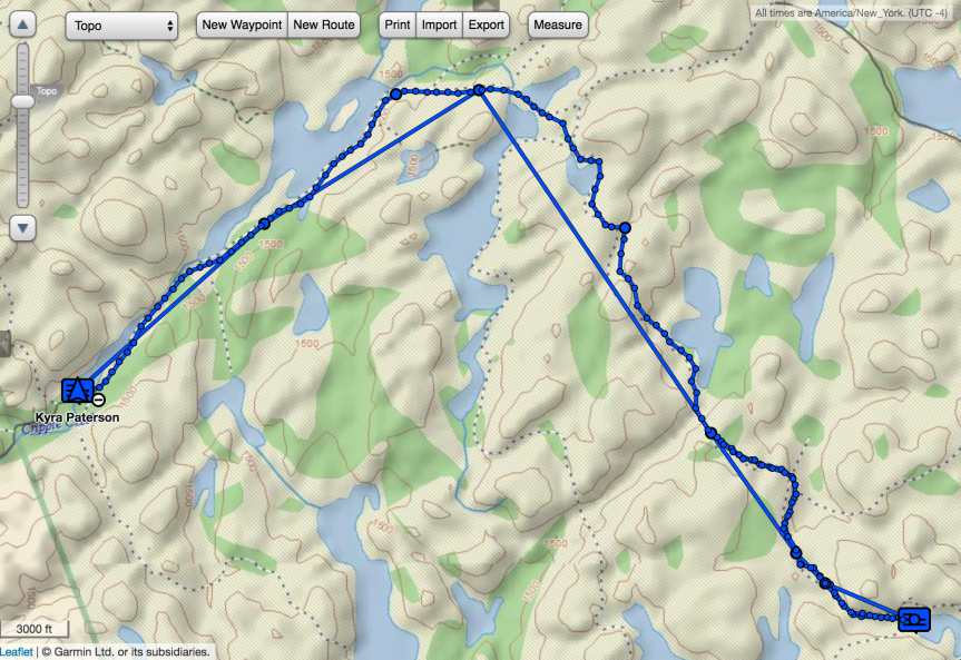
Day 1: Rain Lake access point to Brown Lake (13-14 km)
After picking up our backcountry permit at the Kearney park office, where we were assured that even low-sitting vehicles have been getting through the Rain Lake road, we headed for the access point! We ate our lunch in our vehicle (and spotted a vole while doing so!), then started our trip.
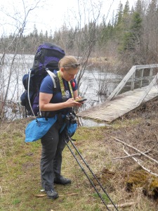
After crossing Rain Lake on a wooden bridge, the trail follows an old railway bed for nearly all of the first 8.7 km, at which point you reach the 3rd (and top) loop of the Western Uplands Backpacking Trail and need to proceed in either a clockwise or counter-clockwise direction (you can also access the trail – and loop 1 – from Highway 60). We were headed for Brown Lake, so we went in a clockwise manner. The next 4 km takes you through the forest, up and down and up again. With all the rain in recent days, the trail was very wet in sections, requiring us to carefully choose our steps so as to avoid getting a soaker. There were also stream crossings to manoeuvre by picking a path along partially submerged rocks and logs. We found the trail lacking in signage, and many times we had to consult our map to figure out which way we should probably go. Since we were hiking so early in the season, there was new growth everywhere in the forest, including on the trail – it hadn’t yet been beaten down by hikers’ feet. So without very many trail markers in trees, we found it quite frustrating at times (suggestion: when the trail turns, put a marker!). Perhaps it would be easier to follow the trail in the summer!
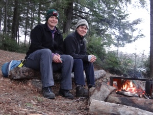
We reached the first campsite on Brown Lake, but having looked at a map posted along the trail, we thought there were 3 campsites and decided to continue to the last one to shorten our hike the next day. We met 3 men at the 2nd campsite, who warned us about a stream crossing they had done earlier, having travelled in the counter-clockwise direction. They said that they had to build a bit of a bridge with trees but that it wasn’t too stable and we might still get wet feet. We continued on to the next campsite, but soon realized there wasn’t one. We returned to the 1st one and settled in, setting up our tent and tarp, and throwing a rope over a branch for a bear bag. We had decided that we didn’t feel like scavenging for wood to make a fire, so opted to not have one at all. I set out to make hot chocolate on our MSR Dragonfly stove, but soon discovered that we had a problem – (insert guilty party’s name here) accidentally packed only 1 of 2 required bottles of chemicals to treat our water (they work together), meaning that we would have to boil all of our water to avoid getting sick from nasty tiny critters invisible to the naked eye. We debated scrapping our plans for hot chocolate so that we could save fuel, but then decided to have a campfire because 1) it wasn’t raining (yet), 2) wood was dry (still), and 3) we may not have brought enough fuel to boil all our water for 1 minute! So we gathered wood, and had a great fire, boiling as much water as we could use for hot chocolate, dinner, breakfast, and to carry with us the next day. We had a delicious dinner of spinach quinoa soup and fresh bannock. Yum. Full menu for the trip is here.
Possibly the best feature of this campsite was the fully enclosed toilet – 3 walls, a door, and a roof! Who cares that the door didn’t shut?! Someone had tied a rope to the handle, and Cheryl modified it so that it could be hooked onto a nail so the door stayed closed. From the outside, we pushed a log against the door to keep the inside dry!
Within 5 minutes of us climbing into the tent for the night, the rain began. With 2 very short exceptions, it continued to rain for more than 40 hours!
We had one Nalgene bottle with us, so we filled it with boiling water, and after Cheryl’s feet warmed up, I had it for the rest of the night. Unfortunately, I was still cold and had trouble sleeping (despite my sleeping bag rated at -7C). In the night the loons were quite loud, but I didn’t mind! We also heard a beaver slapping its tail against the water a couple of times.
Day 2: Brown Lake to West Otterpaw Lake (6.5 km)
We woke up to pouring rain, so we cooked our breakfast under our tarp. We packed up camp, and set out for West Otterpaw Lake.
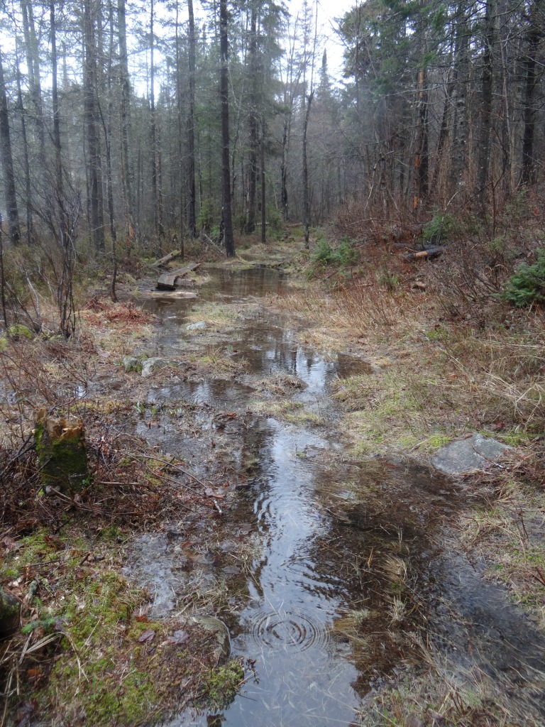
We knew that we would encounter the stream that the guys warned us about “just around the corner”. Turns out we hiked for quite a long time before we found it. Rather than crossing the stream where they had apparently cut down a live tree (!) and lay it across the water, we chose to cross further downstream, where we could use a combination of partially submerged rocks and logs to cross. Would the rocks be slippery? Would the logs move? We picked our way slowly, very slowly across the stream, and safely made it to the other side. I was very thankful for my hiking poles! It would have been next to impossible to cross without them.
The temperature was such that whenever we stopped, even to quickly eat a snack, we got cold. It took hiking for 10 minutes or more to warm up again. Unfortunately, Cheryl and I brought shells for our gloves that eventually soaked through, meaning that we couldn’t keep our hands dry and warm. I had extra pairs of gloves, but if I wore them in the pouring rain, they would be soaked within seconds!
When we originally planned out and reserved our route, we fully intended to hike 16 km on Day 2, going the long way past East End Lake and Loft Lake before arriving at West Otterpaw Lake.
But then driving up to Algonquin, we wondered whether we really wanted to hike 16 km. We decided that we would figure it out as we were hiking. In the end we decided to shorten our hike by walking along a portage to Lady Slipper Lake, and following the trail to Gervais Lake and then West Otterpaw Lake. We thought that we would set up camp and then go for a day hike, hiking along part of the trail that we had originally intended to cover. However, once we arrived at camp, we had no desire to go anywhere. It was still pouring rain, and after setting up camp, we climbed into our sleeping bags, eventually got warm, and never wanted to leave them!
From 2 PM until we went to sleep that night, we tried to keep warm in the tent, going out only a couple of times to use the toilet and hang our food bag. And by toilet I mean seat without a lid, which meant that it was soaking wet wood that I refused to sit on – instead, I hovered.
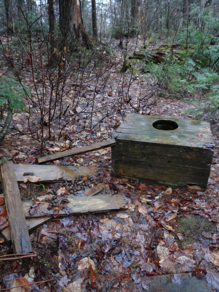
It was raining so hard that as soon as you pulled your pants down, your backside and exposed clothing started to get wet! Not fun.
At some point that afternoon, I think, I spotted a hare between our tent and the toilet. It was very cute, hopping off into the woods.
While we had originally planned a 4-day trip, we started discussing options for shortening our trip. We could pack up right away and hike as far as we could back in the direction we came, spending the night on another lake and hiking the rest of they way out the next day. Or we could wake up early the next day and hike 20 km out to our vehicle. Or we could continue with our trip, facing another full day of hiking in the pouring rain, where the temperature was expected to drop again, and where we weren’t sure whether our rain gear would eventually soak through with all the rain! Our plan had been to stay on Weed Lake that 3rd night. We were worried though that our fleece sweaters would get wet and we would lose our layer of warmth. And to be perfectly honest, camping in freezing temperatures in pouring rain is not fun! I would rather have had colder temperatures and snow. At least we would have been dry and been able to wear gloves. That evening, while out of the tent to hang our bear bag, it started to snow! It was a rain/snow mix.
We decided to head home early, getting up at 6 AM the next day and hiking 20 km out to our vehicle. This would be further than either of us had ever hiked with 35+ pounds on our backs. We knew that it was doable, with the last 8+ km mostly flat.
We also scrapped plans to cook any more meals, not wanting to hang out in the cold under our tarp to cook. Instead, we poached our snacks and no-cook lunch from Day 4, and ate those for dinner and breakfast the next day.
Once again we filled our Nalgene bottle with boiling water, and this time, despite the cooler temperature, I slept better!
Day 3: West Otterpaw Lake to Rain Lake access point (20.7 km)
We were up at 6 AM and on the trail by 7:20 AM. Packing up the tent and tarp takes longer when your hands are frozen and don’t work right! Our rain coats and pants were still soaking wet in the morning – they hadn’t dried off at all overnight (not surprising).
Using my new Garmin InReach SE+, a satellite communicating 2-way messaging device that can also summon emergency assistance (rescue), we informed our families that we had modified our route and were intending to hike all the way out that day. They confirmed that they had received the messages. So far, I love my InReach!! Peace of mind for me and my family.


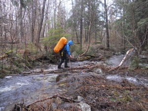
Hiking out the way we went in meant that we would have to do the stream crossing again that was a little harrowing the first time (it probably took us 30 minutes to figure out where to cross safely!). However, I found it easier the 2nd time, maybe because I knew I could do it. We eventually arrived at our Day 1 campsite, and used the luxurious toilet with a roof and door! We continued on our way, and were later stopped in our tracks when we reached a stream that was totally impassible – without walking through it! We spent a while – a long while – walking upstream and downstream, evaluating our options for crossing it. We couldn’t remember how we did it on the way in, but figured the water was so swollen that likely we just picked our way easily over rocks. But now, we had to weigh the options – cross over rocks with fast flowing current, and steps a little too long for our liking? Or precariously balance along a log 2 feet above the stream (not in my lifetime!)? Or take our gaiters, boots and socks off, roll up our pants, put on our sandals and walk through the stream. Yup, the last option. The water was cold, but not quite as freezing as I expected it to be. I was worried that we wouldn’t warm up! But we used our quick dry towels to dry our feet and continued on our way! Phew.
And speaking of gaiters, we were so happy to have brought them. Several times we had to step into puddles or streams and never once did I get a wet sock! Love my Outdoor Research gaiters and my Salomon Quest hiking boots!!
Once we reached the old rail line, we knew we would make it to our vehicle! However, the last few km’s were hard on our feet. The packed ground was surprisingly painful. It seemed that the end would never come. The pouring rain continued, and each time we turned the corner, we saw more trail… we thought the bridge would never come!
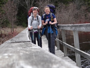
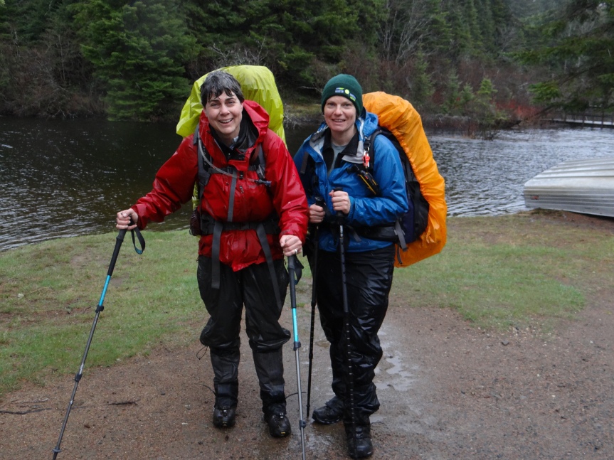
But finally, we spotted the bridge! A couple of guys heading out on a canoe trip were at the access point, and one of them agreed to take our picture. Amazingly, I was still dry under my wet rain coat and pants!
Another time, I would not set out on a trip with such a terrible weather forecast. We were colder than during our winter snowshoeing trip this February.
Nevertheless, this trip presented us with several challenges that we were able to overcome! Algonquin, I’ll be back!
I saw today that Algonquin has closed the Western Uplands Backpacking Trail and the Highland Backpacking Trail due to flooding – I’m not surprised!
Follow me on Facebook: Kyra on the Go: Adventures of a Paddling Triathlete
Follow me on Twitter: @kyrapaterson

Spinach quinoa soup , yum , really?
LikeLiked by 1 person
Yes! I’ll make it for you sometime. And even if you didn’t like it, on a wet, cold camping trip you’d eat anything that someone else made for you!
LikeLike
You used the word ‘harrowing’. I agree. Problem solving trip but too cold and wet for fun.
LikeLiked by 1 person
Yes, the fun factor kind of disappeared after Day 1. 🙂
LikeLike
Great post and good job! I was supposed to be on a kayak/canoe trip but my camping partner for the trip got a stomach bug the day before we were to set out. I was ready to wear my drysuit all weekend! LOl. Glad you made it back safely!
LikeLiked by 1 person
I should have brought my neoprene paddling gloves with me!! And my skull cap! 🙂
LikeLiked by 1 person
LOL I was thinking that when i was reading! LOl. I had mine packed but never got to use them.
LikeLiked by 1 person
Love the pics! Especially the pink sunset!
I’m gonna have to take this trail one of these days 😊
LikeLiked by 1 person
Thanks!! 🙂 And yes, check it out… when it’s dry!
LikeLiked by 1 person